
Learn to Read the Clouds
Perhaps the greatest challenge to any survival situation is dealing with the weather. Depending on your geographic location and altitude, the weather can be your best friend or your worst enemy. This is why it is so important to have some basic knowledge about the weather. Additionally, you can make some accurate weather predictions by reading the clouds. You can learn to read the clouds in less than one hour.
You do not have to be a meteorologist to be able to make some basic predications concerning the weather. You just need to be familiar with some basic types of clouds, why they form, and what that means as far as impending weather conditions. Understanding how clouds are named and correlating that with what you see can help you make reasonably accurate weather predictions.
How Clouds are Formed
The most important thing to remember is that as air rises it cools. As the air cools, it can no longer hold as much moisture. When the air cools enough, the water vapor condenses into water drops or turns into ice crystals. This is what forms the clouds that we see.
How Clouds are Named
Clouds are given Latin names that correspond to their appearance and their altitude. They are also categorized based on whether or not they will produce precipitation. There are 10 basic cloud types that you should recognize as they all mean different things as far as the weather is concerned. Here is some basic Latin that describes how clouds are named:
- Stratus: This is a layered cloud. They generally have flat bases and tops. They can extend to the horizon.
- Cumulo: This type of cloud is as tall or taller than they are wide. These clouds appear lumpy and piled up, sort of like a cauliflower. The Latin root “cumulo” means heap.
- Cirro: This Latin root words means “curl”. These are typically very high clouds composed of wispy ice crystals. They are higher than 20,000 feet which is why these clouds are composed of ice crystals.
- Alto: This Latin root means “high”: These clouds are in the middle of the atmosphere, about 6,500 feet to 20,000 feet.
- Nimbus: This Latin root means “rain”. Nimbus just denotes a cloud that produces precipitation.
Ten types of clouds based on the Latin nomenclature
High clouds, above 20,000 feet: cirrus, cirrostratus, cirrocumulus
Mid range clouds, 6,500 to 20,000 feet: altostratus, altocumulus
Low level clouds, below 6,500 feet: cumulus, stratus, stratocumulus, nimbostratus, cumulonimbus
Correlating clouds with weather
It is likely easier to organize this information based on the altitude of the various clouds. Once you understand the types of clouds that exist at various altitudes and why, it becomes easy to make some basic predictions.
High Clouds
High clouds range in altitude from 16,000 to 43,000 feet. Due to their extreme altitude they are comprised mostly of ice crystals. Most people either view these clouds while looking out the window of an airplane or they encounter them while hiking on a very high mountain. These high clouds do not typically block the sun light. There are three types of high clouds.
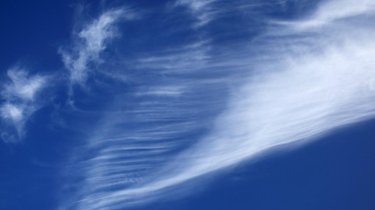
Cirrus clouds: These are high clouds that are the first indication of an approaching depression. You may hear the term “mare’s tails” which are wispy streaks formed from ice crystals that fall beneath these clouds. Expect precipitations in 12 to 24 hours.

Cirrostratus: These are high clouds composed of ice crystals that typically form a thin layer or veil. They often cover the entire sky and will produce a halo around the sun or moon. These clouds indicate that a depression is getting closer. You can expect rain, wind, or fog in about 10 to 15 hours.

Cirrocumulus clouds: These are high clouds that sometimes form ripples. They are an indication of fair weather and will often clear off into blue sky.

Mid Range Clouds
These clouds form at an altitude ranging from 6,500 to 23,000 feet. They are comprised of water and/or ice depending on the altitude. These clouds often block the sun but not always.
Altostratus clouds: These clouds are rather featureless and form a grey veil over the sun or moon. Due to the veil, the sun or moon may appear to have a halo. They last about fours hours, after which they will thicken into rain bearing clouds, typically nimbostratus. These clouds indicate a depression will arrive in 8 hours or less.
Altocumulus: These are fair weather clouds that often occur after a storm.

Low Clouds
These types of clouds form below 6,500 feet. There are several different categories of low clouds which indicate various weather conditions.
Cumulus clouds: If these clouds are scattered, it means fair weather, especially if they are wider than they are tall. If they occur later in the morning, chances are there will not be any rain that afternoon. However, watch these clouds closely. If there is vertical growth that produces a cloud that is taller than it is wide, watch out for rain.

Stratus clouds: These are low altitude clouds, below 6,500 feet. They form a fog like layer and produce some drizzle. They usually burn off by the afternoon and the day turns out nice.

Stratocumulus clouds: These clouds can cover the entire sky. Their presence generally means dry, stable conditions at least for a few hours. They are capable of producing light rain.

Nimbostratus clouds: These are low blankets of clouds and mean rain or snow for several hours.
Cumulonimbus: These are spectacular towering clouds that indicate rain is eminent. They are flat on the bottom and billow upwards.


Putting it all together
All that information sounds really important. But, how do you put it to practical use? There is a real simple way to do that. But the first thing you need to do is go outside and look up at the sky.
Can you see the sun or the moon through the clouds?
YES!
Look at the shape and color of the clouds.
If cirrus clouds with “mares tails” are present, these are high altitude clouds. (See photos above.) A depression is approaching within 12 to 24 hours. If you see a thin veil that forms a halo around the sun or moon, these are cirrostratus clouds. This means the depression is closer and you will see some weather within 10 to 15 hours.
Long streaks (mares tails) can give you some indication of the direction of the approaching front. Also, closely observe the clouds to see if they are moving. If the clouds appear to be stationary the storm front may not arrive for more than a day. If they are obviously moving, you are looking at bad weather even sooner.
If the clouds are low and fluffy, with a base wider than they are tall, these are low altitude Cumulus clouds. If these clouds are scattered, it means fair weather. However, watch them for any vertical growth.
If these clouds cover most of the sky, these are Stratocumulus clouds. Their presence generally means dry stable conditions but they can produce some light rain.
If the clouds are towering and much taller than they are wide, these are Cumulonimbus clouds. Watch out for the potential of severe weather.
Can you see the sun or the moon through the clouds?
NO!
Look at the shape and color of the clouds that are covering the sky because there are mid range and low level clouds that will cover the entire sky.
Clouds that form a thin veil, perhaps forming a halo around the sun or moon are Altostratus, which are mid range clouds. They are rather featureless and thicken into rain bearing clouds. They indicate that a depression is approaching in 8 hours or less.
Clouds that form a thick veil and engulf mountains and buildings, are Stratus clouds. Expect drizzle or light snow depending on the temperature.
If the clouds are a low, dark, grey sheet, it is likely already raining. These are Nimbostratus clouds, the everyday rain cloud. Expect rain or snow for several hours.
Additional Information
The fantastic thing about cloud watching is that you can make some basic weather predictions without any special equipment. It is also not difficult to learn the terminology. All of this can be done in less than an hour. My best advice is to take the time to learn this skill then get in the habit of watching the sky every day.
For more information, view one of the following links below.
The Globe Program has a very nice PDF for download. Go here.
The National Weather Service, in conjunction with NASA, also has a very nice concise and informative PDF. Go and download their cloud chart.
You can also get a free EBook on different cloud types. But you will have to submitt your email address. If interested, go to Whats This Cloud.
I hope this post has been helpful.
Additional Posts of Interest
The Ten Essentials Needed for Survival
How to Choose the Best Water Filter
Go off grid and live well,
Patrick
Stay connected with us to receive regular updates.
Join our mailing list to receive the latest news and updates from our team. We always respect your privacy. Your information will never be shared.
Patrick

Sustainable Living Expert
Author
Having grown up with 2 working farms in the family, I was active outside from a young age. I have lived off the grid for over 20 years and still going strong. I would love to teach you the skills of sustainable living and all else that is needed for you to be secure in managing your own resources.
Get regular updates and exciting new articles.

